C-ARD: Raw to Corrected Analysis-Ready Data
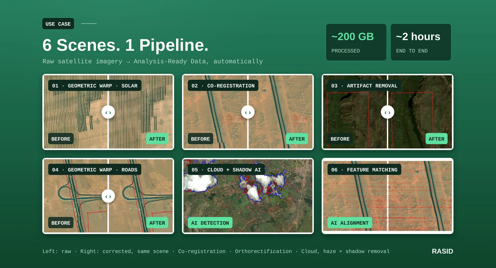
An AI pipeline that automatically corrects geometric distortion, radiometric inconsistency and cloud, haze and shadow in high-resolution satellite and aerial imagery, processing around 200 GB in about two hours.
Analysis-Ready Data · Orthorectification · Cloud Removal
The problem
Satellite-imagery providers lose usable captures to three recurring defects. Geometric distortion brings terrain distortion, sensor-angle artefacts and spatial misalignment between imagery layers. Radiometry is inconsistent, producing colour imbalance, brightness variation and inconsistent spectral response across image tiles. Cloud cover, haze, shadow and atmospheric distortion obscure ground features outright. Together these lead to high rejection rates from end-users in defence, agriculture, urban planning and environmental monitoring, and manual correction is time-consuming, costly and not scalable.
The approach
C-ARD (Corrected Analysis Ready Data) is an AI-powered system for automatic geometric and radiometric anomaly correction in high-resolution satellite and aerial imagery. It works in two directions: it transforms raw data into Analysis-Ready Data (ARD), and it refines existing ARD products to eliminate residual errors. Three deep-learning capabilities sit at its core: image matching and co-registration; cloud, shadow and haze detection and removal; and radiometric colour enhancement. RASID built it for satellite and aerial imagery providers, to be dropped into the pipelines they already run.
Inside the pipeline
The satellite and aerial image-quality pipeline automates detection, correction and patching in three stages: anomaly detection, anomaly correction, and co-registration and patching. Detection flags the tiles within a scene that carry artefacts, so correction and review are targeted at those areas rather than the whole capture. Correction then applies the appropriate model to each flagged region. The corrected patches are co-registered and stitched back in so they align with the surrounding imagery. The pipeline works on individual scenes and on bulk imagery alike.
Correcting geometry
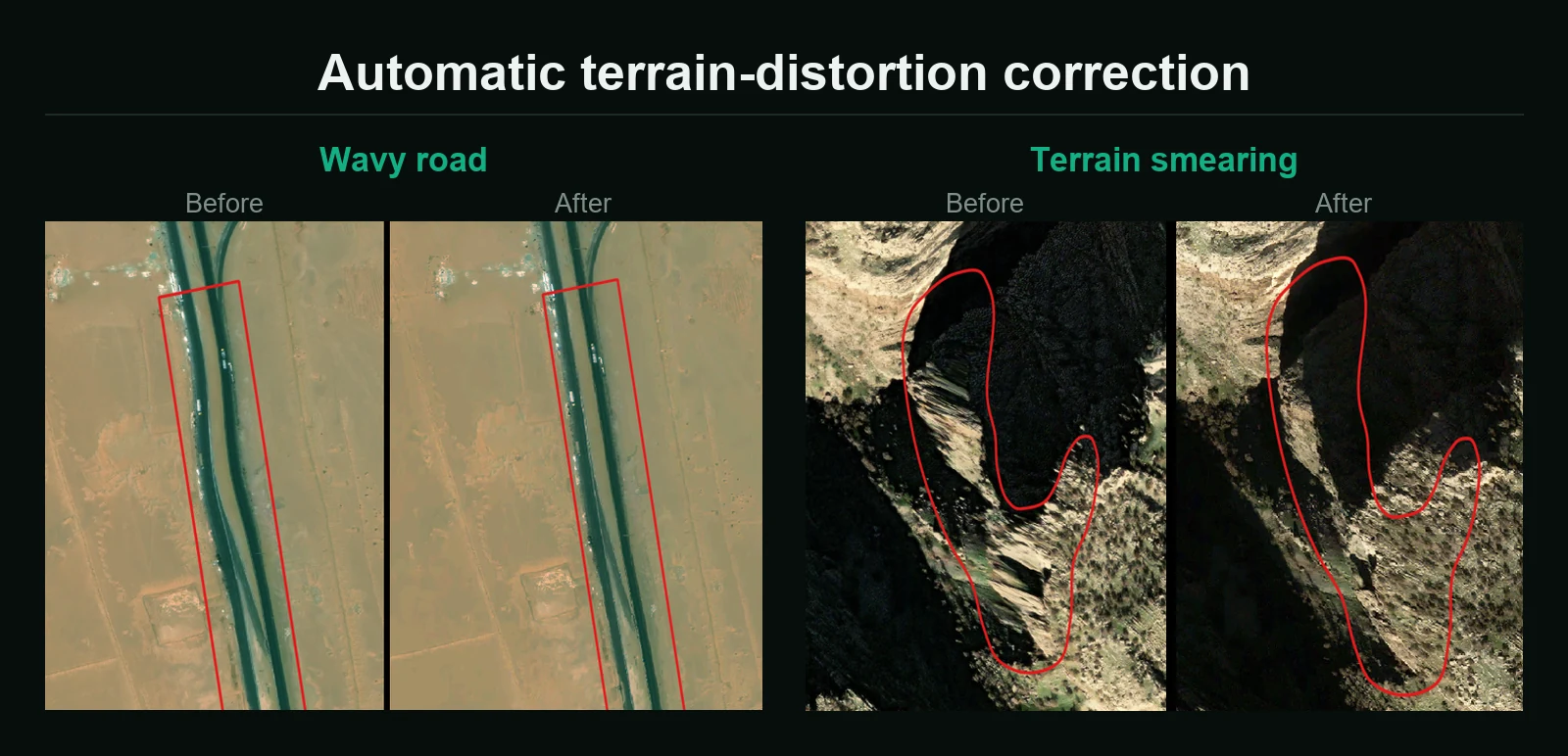
Geometric correction uses AI-enhanced orthorectification and co-registration to remove terrain-induced distortion. Two artefact classes recur in high-resolution captures: wavy roads, where a linear feature such as a highway develops a lateral ripple, and smearing, where steep terrain drags surface texture into streaks. C-ARD detects and corrects both automatically, straightening linear infrastructure and restoring texture on slopes.
Clearing cloud, haze and shadow
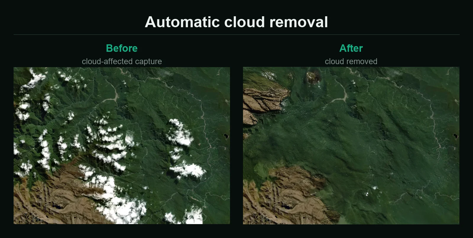
Atmospheric correction splits into detection and removal. Cloud detection supports both high- and low-resolution imagery, with models adapted for RGB, RGB-NIR and multispectral inputs (so the same capability can be applied across a mixed sensor fleet rather than only to scenes with a full band set), and the detection output distinguishes thick cloud, thin cloud and shadow. Removal then offers two routes: removal by replacement, which substitutes the obscured area with valid observation, and removal using generative AI, which reconstructs ground detail where no clean replacement is available. Haze is handled by the same detection-and-removal capability.
Radiometry and the raw-to-ARD path
Radiometric enhancement covers colour correction and normalisation, so that brightness, hue and spectral response stay consistent across image tiles. The same route covers the raw-to-ARD transformation: as the processing chain shows, panchromatic and four-band multispectral imagery are each calibrated to top-of-atmosphere (TOA) values, then fused into a single pansharpened product. What arrives as separate uncalibrated bands leaves as one consistent, analysis-ready image.
Human in the loop
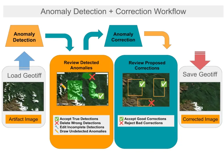
C-ARD is not a black box. An interactive GUI places an operator between detection and delivery. The analyst loads a GeoTIFF, reviews the detected anomalies (accepting true detections, deleting wrong ones, editing incomplete detections and drawing anomalies the model missed), then reviews the corrections the system proposes, accepting the good ones and rejecting the bad before saving the corrected GeoTIFF. Automation removes the repetitive work; the decisions stay with the operator.
Deployment and results
C-ARD is built for scalable deployment: as a cloud service, on-premises alongside existing imagery pipelines, or in orbit as EC-ARD, an edge-compatible version. The pipeline detects and corrects anomalies in near real time, processing around 200 GB of imagery in about two hours. The value it is designed to deliver for imagery providers is fourfold: turn more captures into sellable imagery, reduce manual correction and QA time, deliver analysis-ready data faster, and provide consistent high-quality imagery.